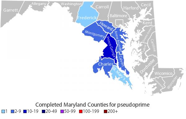
 Well, now that I'm back geocaching, I wanted to return to one of my favorite secondary activities -- slicing and dicing the statistics about the geocaches I've found. I had previously sung the praises of the "It's Not About the Numbers" web site. Here's a county-by-county map of Maryland I generated in June 2008 using that site.
Unfortunately, INATN shut down in June of 2010. So with my renewed interest in geocaching, I had to find a new way of getting my map/stats fix.
After reading the geocaching forums, my best option seemed to be downloading the GSAK (Geocaching Swiss Army Knife) program. Someone even posted the approximate INATN color scheme, which I plugged in to get a similar map.

I don't think the map looks as nice (and I'm irritated by the labeling of St. Mary's County as "Mary's"), but it'll have to do. I'll probably pay to register the program, since I was willing to contribute a few bucks to keep INATN alive a few years ago.
The difference in the two maps from a content perspective is the second cache I found in Frederick County in July 2008.
I have to amend my praise for the geocaching Android application a little bit since the last post. While on a break during a conference in North Carolina last weekend, I attempted to find a cache that would allow me to color in NC on the national map. The GPS receiver on the phone wasn't all that accurate, and it killed my battery. The one I found it Maryland was great because looking at the satellite view in Google Maps was good enough. For future use, though, I think I'll carry my Garmin receiver in addition to the phone, so I can punch in the coordinates for more accuracy (and battery life).
No comments:
Post a Comment